NGI Research Contributes to NOAA's Improved Hurricane Forecasting Capabilities
September 25, 2023
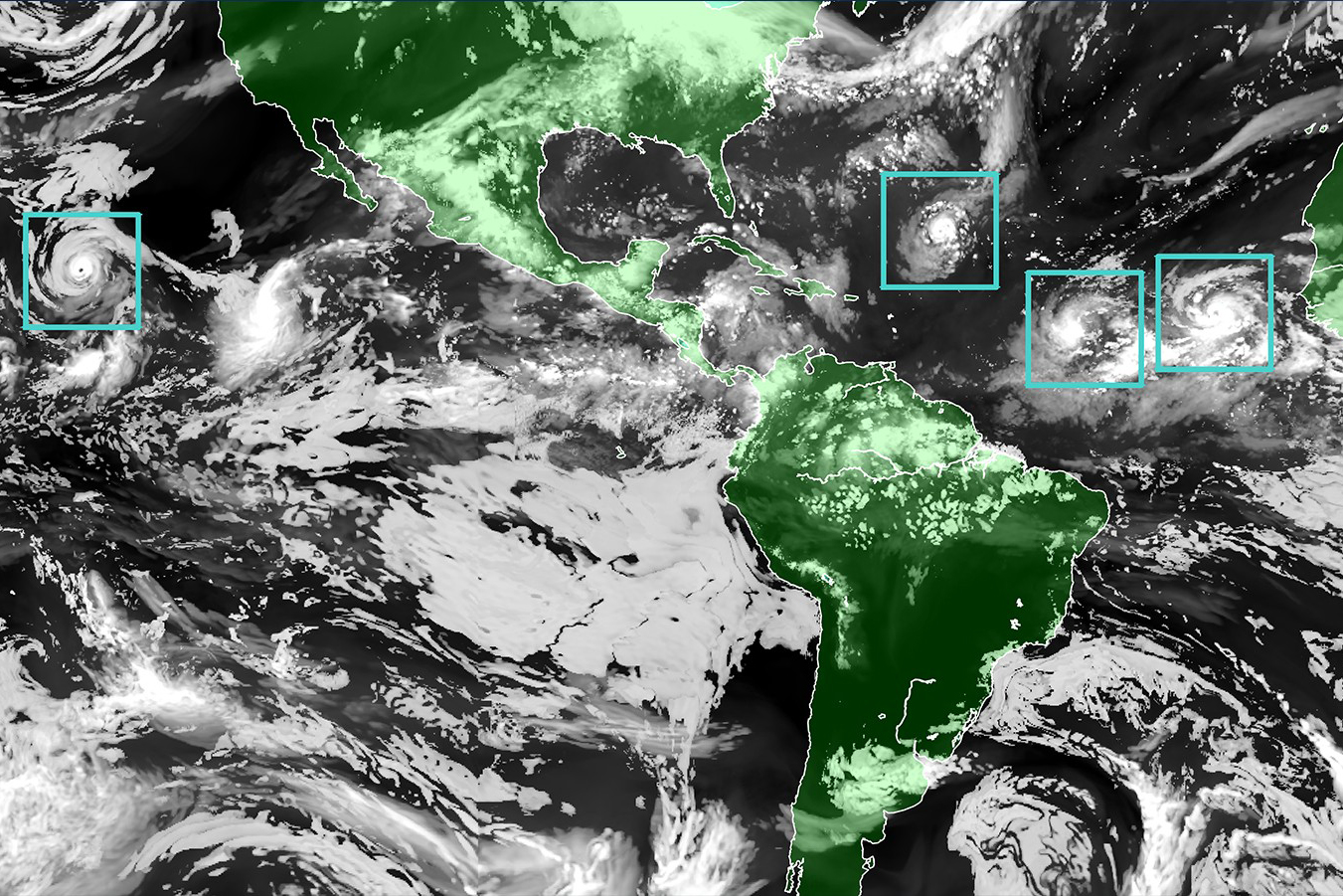
The Hurricane Analysis and Forecast System (HAFS) "moving nest" Model. Green areas are land, black areas are water, white areas are clouds, and blue-green boxes that represent the moving nest model outline tropical storms. (Image credit: NOAA)
This summer, the National Oceanic and Atmospheric Administration (NOAA) launched a new
Hurricane Analysis and Forecast System (HAFS) to run alongside existing models for the 2023 season before replacing them as its premier hurricane forecasting model. The HAFS is expected to
improve forecast accuracy, leading to reduced storm impacts to lives and property.
Scientists with the Northern Gulf Institute (NGI) have been supporting NOAA's efforts to improve its hurricane forecasts and outlooks. In collaboration with the Atlantic Oceanographic and Meteorological Laboratory (AOML), recent NGI research accomplishments include improving predictions of rapid storm intensification in the HAFS, improving accuracy of surface wind data collected by hurricane hunter aircraft that forecasts use, and incorporating an improved seasonal hurricane outlook into the Climate Prediction Center's (CPC) operational model.
For better predictions of rapid storm intensification, meteorologist Xiaomin Chen and his colleagues focused on improving the representation of chaotic, swirling winds just above the ocean in the forecast model. While these small-scale swirling winds play a key role in driving a storm's intensity, kilometer-scale model grids that are needed for wide-spanning hurricanes cannot directly resolve them. To address this, they developed a new Planetary Boundary Layer (PBL) scheme, which combines atmospheric data collected near the ocean's surface during previous hurricanes and a large-eddy simulation model that uses a smaller model grid. The result is that this new PBL scheme provides a technique that models use to account for small-scale winds, which improves the accuracy of how boundary-layer wind turbulence is represented in HASF predictions. This effort's next focus is on investigating the role of mass fluxes in hurricane simulations to improve their representation in high-wind conditions and on analyzing HAFS forecasts during intensification. Forecasts of ocean coupling processes, storm surge, precipitation, and others can benefit from the new PBL scheme as it improves the surface wind accuracy in models needed for these types of predictions. Read a 2022 article about this research in
Making the Unpredictable Predictable in Hurricane Forecasts.
To improve the accuracy of surface wind data, meteorologist Heather Holbach and her colleagues focused on refining the Stepped-Frequency Microwave Radiometer (SFMR), which collects wind speed data on hurricane hunter aircraft. Previous research provided insights into factors affecting data accuracy, such as measurements of heavy rainfall, which helped focus their efforts on improving the algorithm that the SFMR uses to estimate surface wind speed. By incorporating tail-Doppler radar data on energy that bounces off precipitation, they were able to improve wind speed estimates by more accurately adjusting for rain impacts. The result is that hurricane forecasters will receive improved data on surface wind speed to analyze and forecast tropical cyclones. This effort's next focus is on gaining a better understanding of how the SFMR algorithm models the energy transfer of precipitation and on developing a method to assess SFMR instrument calibration for consistent data archiving. More accurate surface wind speed estimates in hurricanes contribute to improvements in other disciplines such as satellite calibration at high winds; estimates of air-sea exchanges of momentum, energy, and mass; preparation of coastal communities for land-falling storms; and safety at sea for the marine community. Read a 2022 article about this research in
Going into the Eye of the Storm for Better Hurricane Predictions.
For improved seasonal hurricane outlooks – which forecast overall hurricane season activity not hurricane landfalls – meteorologist and climatologist Andrew Mercer and his colleagues identified large-scale steering flows that influence tropical cyclone tracks, which helps predict the frequency of hurricanes that make landfall. To identify those influential steering flows, Mercer extended work by
West et al., 2022 that provided insights into how sea surface temperature (SST) affects tropical storm development. The result is a new tropical Atlantic-Pacific SST index that skillfully predicts Atlantic hurricane activity and is now part of an operational model in the NOAA/CPC outlook, which is widely used by stakeholders to manage the risks of tropical cyclones. This research involved collaboration between several communities – tropical meteorology, physical oceanography, weather/climate forecasting, and risk management – which was pivotal in the transition to an operational model. This effort's next focus is on improving the measure of forecast uncertainty by using algorithms based on predictive machine learning/artificial intelligence to refine the model and produce experimental seasonal outlook forecasts of U.S. landfalling hurricanes for 2024.
The
Atlantic Oceanographic and Meteorological Laboratory is a federal research laboratory in Miami, Florida and is part of NOAA's Oceanic and Atmospheric Research line office. AOML studies the Earth system, focusing on the Atlantic Ocean's role in climate change and the impacts of global changes on the Atlantic Ocean region, to inform accurate forecasting of extreme weather and ocean phenomena, management of marine resources, and an understanding of climate change and associated impacts.
The
Northern Gulf Institute is a NOAA Cooperative Institute with six academic institutions located across the US Gulf Coast states, conducting research and outreach on the interconnections among Gulf of Mexico ecosystems for informed decision making. The AOML Director serves as the NOAA Technical Program Manager for NGI; thus, AOML is the NOAA laboratory with which NGI works most closely.
By
Nilde Maggie Dannreuther, Northern Gulf Institute, Mississippi State University.
