NGI Researcher Chen publishes article: Performance of an Improved TKE-based Eddy-Diffusivity Mass-Flux (EDMF) PBL Scheme in 2021 Hurricane Forecasts from Hurricane Analysis and Forecast System
December 20, 2022
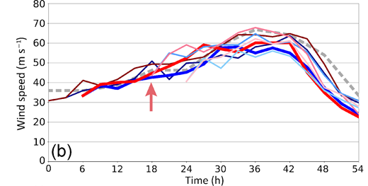
Figure 1: Intensity forecasts from the original (blue tone) and modified (red tone) versions of HAFS for Hurricane Ida, initialized at 12 h, 6 h, +6 h, and +12 h relative to 12 UTC 28 August. The arrow shows when the intensity of Ida in the original and modified versions of HAFS began to diverge, with the modified PBL physics leading to a stronger storm despite similar track.
Online, December 2022
Authors: Xiaomin Chen, Andrew Hazelton, Frank D. Marks, Ghassan J. Alaka, Jr, and Chunxi Zhang
Significance Statement: This study examined how changes to the planetary boundary layer (PBL) scheme based on information from large-eddy simulations affected hurricane model forecast performance during the 2021 Atlantic hurricane season. The modified PBL scheme produced more realistic storm structures, on average, when compared to best-track information and observations from Hurricane Hunter Aircraft. The modified PBL physics also produced better forecasts of rapid intensification. The findings showed that, in the future, we need to work to adjust PBL and cumulus schemes together, "unifying" them for the most accurate tropical cyclone prediction.
Summary:
Computer models forecast the weather on a series of regularly spaced points. The computer time needed to make forecasts increases as the forecast points get closer together. To create forecasts quickly, we create forecasts at points that are relatively far apart; but that requires approximations to the small-scale features in the models, what we call parameterization schemes.
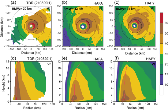
Figure 2: a) Wind speed (|V|) analysis at 2 km altitude from airborne Doppler radar data from a NOAA P-3 Hurricane Hunter mission into Hurricane Ida on 29 August 2021, b) the 2-km wind-speed forecast from HAFA c) The 2-km wind forecast from HAFY. Note the smaller RMW that is closer to the observations in a). d) Average wind speed (vt) around the center of Ida from the analysis of airborne Doppler radar data from the same flight (with the RMW at each height shown in red), e) the same calculation from HAFA, and f) from HAFY. Note the stronger wind field and that the strong winds extend higher into the atmosphere in HAFY compared to HAFA, closer to the TDR analysis.
Air flowing into tropical cyclones in the lowest 1 - 2 km of the atmosphere, what we call the planetary boundary layer or PBL, is the main source of heat and moisture that allows the system to intensity and maintain itself. It is very important to understand how the transfer of heat and moisture occurs, especially for modeling and predicting tropical cyclone evolution. We need to observe what is happening to understand it, but we have limited observations in the PBL due to the safety of flying close to the ocean surface. So, to understand the small-scale processes, we used a new technique based on a large-eddy simulation (LES), a research computer model run with points close enough together so that the processes do not need to be approximated. We examined how a modified scheme in NOAA's new Hurricane Analysis and Forecast System (HAFS) changed the model's forecasts of hurricane track, intensity, and structure. HAFS is scheduled to become an operational hurricane model as soon as 2023, and these modified PBL physics have been included in the version of the model that is being tested.
We ran HAFS with the modified PBL physics (HAFY) for the 2021 Atlantic hurricane season, and compared it with the default (HAFA) configuration. In addition, we looked at a few cases in more detail, like Hurricanes Ida (Fig. 1) and Henri. We compared the model forecasts of Ida with Doppler radar data collected during NOAA P-3 Hurricane Hunter flights into Ida to learn why the forecasts were improved. Henri was investigated to learn why the new scheme had track forecasts that were worse than those using the old scheme and how to improve them. The findings showed that, in the future, we need to work to adjust PBL and cumulus physics (how the model approximates thunderstorms and the heat they generate) together, "unifying" them for accurate tropical cyclone prediction.
Important Conclusions:
Intensity and structure forecasts from HAFY were 10-15% better than those from HAFA, especially early in each forecast. This was because the inflow (air flowing into the hurricane at low levels) was stronger and more realistic in HAFY than in HAFA.
HAFY was also able to better forecast rapid intensification and produced a deeper and more realistic circulation (Fig. 2) than HAFA,
Model forecast tracks were not changed significantly by the modified new physics, but some forecasts of Hurricane Henri were made slightly worse. This shows that the interplay between the cumulus physics and PBL physics can be very important for TC track forecasts.
Full abstract:
Continuous development and evaluation of planetary boundary layer (PBL) parameterizations in hurricane conditions are crucial to improving tropical cyclone (TC) forecasts. A turbulence kinetic energy (TKE)-based eddy-diffusivity mass-flux (EDMF-TKE) PBL scheme, implemented in NOAA's Hurricane Analysis and Forecast System (HAFS), was recently improved in hurricane conditions using large-eddy simulations. This study evaluates the performance of HAFS TC forecasts with the original (experiment HAFA) and modified EDMF-TKE (experiment HAFY) based on a large sample of cases in the 2021 hurricane season. Results indicate that HAFY has better intensity and structure forecast skill overall than HAFA, including during rapid intensification. Composite analyses demonstrate that HAFY produces shallower and stronger boundary layer inflow, especially within 1–3 times the radius of maximum wind speed(RMW). The stronger inflow and more moisture in the boundary layer contribute to stronger moisture convergence near the RMW. These boundary layer characteristics are consistent with stronger, deeper, and more compact TC vortices as well as a more humid mesoscale core in HAFY than in HAFA. Nevertheless, track skill in HAFY is slightly reduced, mostly attributable to the cross-track error from a few early cycles of Hurricane Henri that exhibited ~400 n mi track error at longer lead times. Sensitivity experiments based on HAFY demonstrate that turning off the cumulus schemes notably reduces the track errors of Henri while turning off the deep cumulus scheme reduces the intensity errors. This finding hints at the necessity of unifying the mass fluxes in PBL and cumulus schemes in future model physics development.
