2021 Forecast: Summer Hypoxic Zone Size in the Northern Gulf of Mexico
May 15, 2021
Abstract
R. Eugene Turner and Nancy N. Rabalais
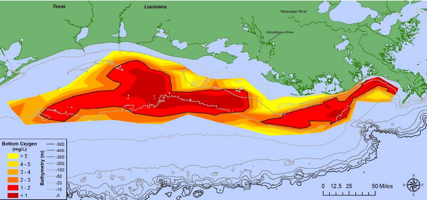
Oxygen concentrations in bottom water across the Louisiana shelf from July 23 – July 29, 2019. Data source: N.N. Rabalais and R.E. Turner, Louisiana State University; funded by NOAA, National Centers for Coastal Ocean Science.
A hypoxic water mass with oxygen concentrations
< 2 mg 1
-1 forms in bottom waters of the northern Gulf of Mexico continental shelf each spring/summer. Nutrients from the Mississippi River watershed, particularly nitrogen and phosphorus, fertilize the Gulf's surface waters to create excessive amounts of algal biomass, whose decomposition in the bottom layer leads to oxygen depletion. The low oxygen conditions in the Gulf's most productive waters stresses organisms and may even cause their death so that living resources are threatened, including humans depending on the fish, shrimp and crabs caught there. Various models use the May nitrogen load of the Mississippi River as the main driving force to predict the size of this hypoxic zone in late July. Our prediction is based on one of these models.
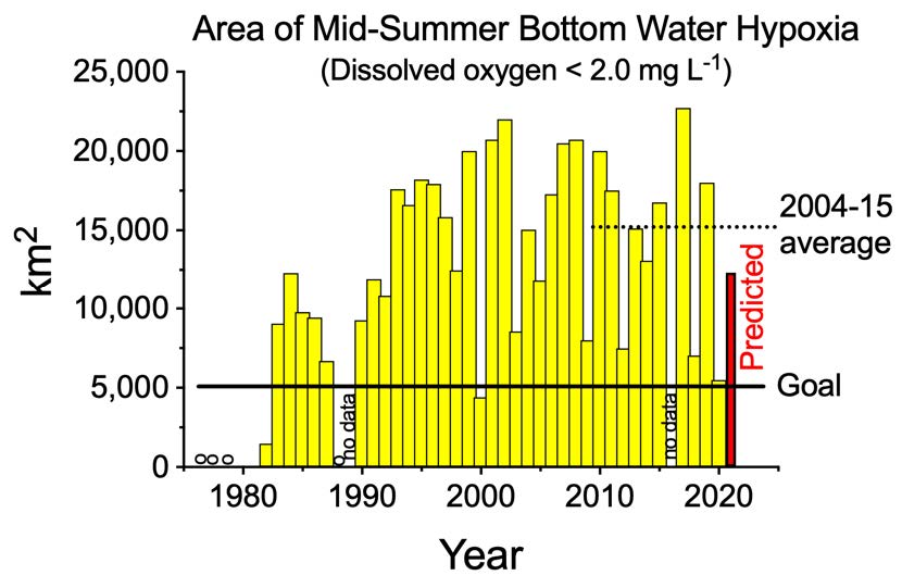
Area of the hypoxic zone from 1979 to 2020. The predicted value for 2021 is the red bar. The Hypoxia Action Plan restoration 'goal' is 5,000 km2.
The June 2021 forecast of the size of the hypoxic zone in the northern Gulf of Mexico for late July 2021 is that it will cover 12,330 km2 (4,761 mi2) of the bottom of the continental shelf off Louisiana and Texas. The 95% confidence interval is that it will be between 10,397 and 14,306 km2 (4014 and 5524 mi2). This estimate is based on the assumption that there are no significant tropical storms or unusual wind events in the two weeks before the monitoring cruise, or during the cruise. If a storm does occur, then the size of the zone is predicted to be 56% of the predicted size without the storm, equivalent to 6,905 km2 (2,666 mi2).
The predicted hypoxic area is about three times the size of the land area of Rhode Island (4,000 km2) and 89% of the average of 13,789 km2 (n = 34 including years with storms). If the area of hypoxia becomes as large as predicted, then it will be 2.5 times the size of the Hypoxia Action Plan goal to reduce the zone to less than 5,000 km2. No reductions in the nitrate loading from the Mississippi River to the Gulf of Mexico have occurred in the last few decades.
Full Document Available Here:
/portal/media/docs/2021/LSULUMCON_press_release.pdf
